For newcomers

At the bottom of each post there is the word "comments". If you click on it you will see comments made by followers, and if you follow the instructions you may also comment and I always welcome that. I have found many people overlook this part of the blog which is often more interesting than the original post!

My blog nick-name is SIR HUGH. I'm not from the aristocracy - my middle name is Hugh which relates to the list of 282 hills in Scotland compiled by Sir Hugh Munro in 1891. I climbed my last one (Sgurr Mor) on 28th June 2009

****************************

Tuesday 24 November 2015

Three northern pensioners claim second ascent of Easington Fell

A call from Bowland Climber (John), had me out on a good nine miler on Sunday. Panic ensues when I have to go south from Arnside into heavy traffic and big town country. John had invited friend Barry whose passion for rocks and minerals had been the subject of anecdotes from John over the years. That was fine so long as Barry didn’t expect me to carry back half a hundredweight of his samples in my rucksack - he turned out to be exceedingly good company and the three of us tramped around, up and over and down the other side of Easington Fell for six hours or so with non-pausing conversation (of the highest high intellectual value of course) - for example, are Higgidy pies good value, and do you walk faster using the 1:25,000 map than you do with the 1:50,000?

I had offered to chauffeur with my car from Longridge to Grindleton, and that might have been a good idea in retrospect  After much driving through scattered villages and country roads in John’s car we eventually arrived at Grindleton. On a steep hill in the village John stopped to survey for a parking spot. When he tried to restart we were informed that the gearbox had long since given up on first gear. It was touch and go boosting revs and torturing the clutch to move off up the hill in second gear - thankfully we were not reduced to manpower.

A series of  footpaths shown on the map, but only identified on the ground by numerous stiles took us to the furthest edges of civilisation.

Leaving behind the grazing pastures we entered  the land of bogs reeds and tussocks and battled on before summiting Easington Fell where lunch was taken. Barry tried to convince John that he had some moral obligation to share his Higgidy pie, but John was not persuaded.

Now, John's predilection for adventure identified a return route on the map dropping into a steep sided, tree filled ravine. There was the merest semblance of a path, but an atmosphere of no human visitation since about 1700.  Ed Stafford struggling down the Amazon from its source sprang to mind.

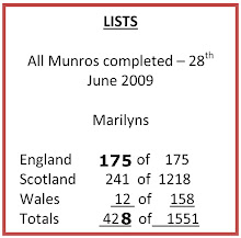
John had done a selling job on the phone, tempting me with the fact that Easington Fell is a Marilyn, but I saw that I had already ticked it off on the list. I had no recollection of climbing it, nor did any recollection return on this Sunday, but when I arrived home I found the reference here to its ascent in March 2014 hidden away in a post covering several events on different days:

http://conradwalks.blogspot.co.uk/2014/03/roads.html 

My approach on that day had been from the opposite direction not far off the road - a quick up and downer, so that probably explains the blank in my memory. Anyway, it was worth going there again in excellent company and with magnificent views across to the main peaks of the Yorkshire Dales. First gear was not needed on the return journey.

-------------------------------------------------
The problem with chopped off text seems to have sorted itself


Map courtesy of Bowland Climber


The horse whisperers

Barry pedantically follows the Country Code keeping exactly to the footpath

The stile constructor's version of Spaghetti Junction

John decides to go walkabout.
 There was a danger of disappearing entirely in the bog here 

The distant summit of Easington Fell, and I was getting hungry

In the wild ravine.
 It was possible to walk underneath this stile without obstruction to the other side of the wire fence
 We could only conclude somebody had a lot of spare wood to use up

Monday 23 November 2015

Test for chopped text

This a test to see if my text is being chopped off at the righthand edge when I post from my iPad using Blogpress. That will mean I have to do quite a bit of typing so I can get a few lines I. I then intend to add a photo, although there is no option for adding captions. You just have to use normal text under the photo.


This a photo of a tractor. I want more than one line here so I can see if any text is missing.


- Posted using BlogPress from my iPad

Pete and Crosthwaite, and two Marilyns


Thursday 19th March (with Pete)

Our weather forecasts are becoming surprisingly accurate. I think the  Met Office recently invested in some expensive computer stuff. Rain was predicted up to 11:00 am and it stopped precisely at that hour as we pulled into a lay-by to start our Thursday walk, and again, as forecast, sunshine prevailed for the duration.

A pleasant walk on roads near Crosthwaite:


Pete thinks I have disappeared

Unusual waterfall


One for Alan R. This appeared to be in current use
- stripped down for racing?

---------------------------------------------------------------------------------------------------------

Saturday 21st Nov.


The first snow of the year arrived. I motored to south Lancashire for two Marilyns near Rawtenstall.  That area features old mills, and much industrial heritage going back to the 18th century nestling in valleys and surrounded by upland, moorland hills scattered with old tracks and quarry workings.


Hailstorm Hill gave me some hard going over snow covered reeds, tussocks and heather until I got onto tracks, but these were also tricky with ice and snow, and I had a few slapstick moments teetering and gyrating with walking poles flying through the air, but fortunately I avoided hitting the deck. The summit was unidentifiable on a mile long, half mile wide stretch of desolate moorland half a mile from any of the tracks. I managed to get the GPS over the spot height shown on the map, took a quick photo and retreated.


A quick drive took me to Shawforth on the A671 from where I ascended Freeholds Top on tracks and paths with a final trek across pathless moorland again with a good covering of snow.


My route went up the side of the snow covered reservoir onto the hills


The featureless summit of Hailstorm Hill

Summit of Freeholds Top - motorcyclists approaching in second photo


I have had a bad time here with Blogger. The photos took on a life of their own and refused to go where I wanted them and then, if I wanted to add captions they just diasppeared, The above is the best I can do, so I'm leaving well alone.

NOW I SEE ALL MY TEXT IS CHOPPED OFF AT RIGHT EDGE - HAVE GOOGLED - OTHERS WITH SAME PROBLEM NO SOLUTION UNLESS GOOGLE DECIDE TO FIX IT - SORRY FOLKS.


Monday 16 November 2015

Diversions

A combination of  poor weather and other circumstances seems to have kept me indoors for a while. That means I have turned to various diversions:

1.  A new Photoshop painting.

Based on Small Water (nr. Haweswater - Lake District)
I have reduced pixels by half for the blog - original would be a bit sharper - CLICK TO ENLARGE
----------------------------------------------------------------------

2. At the request of daughter High Horse I  made a rubber band pin board for Katie.


----------------------------------------------------------------------------------


3. And more Photoshop playtime - have you noticed my new avatar?


This was the orginal but the figure was too small on the avatar so he had to be cropped


----------------------------------------------------------------------------------

Friday 13 November 2015

Running out of routes

Thursday walks with Pete continue. Yesterday I was able to put the OS mapping on my new iPhone 6s Plus to the test. I have bought Memory Map OS Great Britain Complete at 1:25,000 in addition to the 1:50,000 which I already had. In the past I have not favoured the 1:25,000 because, even though the scale is larger, a lot of the print is small and difficult to read. With iPhone the map can be magnified enabling easy reading of even the tiniest detail, and that combined with the huge advantage of showing field boundaries now makes it a winner. Another amusing feature is the illusion of travelling faster over the ground on the larger scale. The only remaining disadvantage is that I do not get a good mental picture of the lie of the land, but it is easy enough to switch back to 1:50,000.

I have been using a combination of the old iPhone 3 and my iPad Mini. The phone screen was a bit small and the iPad a bit cumbersome. The new iPhone Plus with its 5.25inch screen is ideal, fitting into map pockets in my various jackets and shirts, and I have bought a waterproof pouch and lanyard (Vansky - IPX8 certified to 100ft) - I reckon that should cover me for the kind of walks I do, but I have doubts about 100ft being adequate for a TGO Challenge - some of those Scottish bogs...

Pete’s rheumatoid arthritis has improved over the months with the treatment he  receives, but we are keeping walks to under 5 miles, and also, in view of saturated fields and muddy paths, we are keeping to Tarmac. I am running out of routes near enough to home to be practical with those parameters, and this Thursday we did a rare repeat. Fortunately I had little recollection of the walk.

I have just looked back at the post and find I was holding forth on the subject of finding new routes then. Click to have a look if you want.

"Where to Next" Jan. 2014

I see also I took the same picture of the River Mint this time, and oddly, the same picture of the same moss covered wall, also photos of stone stiles on both occasions, but I had no memory of the close proximity of pylons to our route. 

This time I was attracted by the long ridge on the south of Borrowdale which I ran a few years ago and also walked on a  fine day with daughter, High Horse.

Old screenshot of Memory Map on my computer showing the many routes we have walked. There are more that got deleted, and others outside this area

River Mint near Patton Bridge - this and the moss covered wall almost identical to photos shown on post January 2014

Moss covered wall - similar photo last time intrigued my American readers


As we approached I reckoned these two pylon lines crossed, one running under the other which is unusual but confirmed a little further on - click to enlarge


Whinfell Tarn (again)

Blue is our Patton Bridge route (clockwise)
Red dots show the fine south Borrowdale ridge. There is a good return track back down Borrow Beck


Sunday 8 November 2015

"Everest, the First Ascent "(not boring)

Everest bores me. But more emphatically, current references fill me with dismay and a mental picture of Base Camp looking more like a refugee disaster than anything to do with my personal reasons for attraction to mountains. And then I see frozen dead bodies and people who have paid huge sums with dubious motives passing by, and then queuing to climb the elaborate fixed ropes on the Hillary  Step.

So, when Gimmer, who comments here, and who is a lifelong friend from school and scouting days pressed an Everest book upon me I was not immediately enthused, but Gimmer's almost hyperbolic recommendation, and insistence that this was something so different and staggeringly revealing had me swayed.

EVEREST, The First Ascent by Harriet Tuckey is the complex biography of Griffith Pugh, a member of the successful 1953 expedition written by his daughter. To say much more would be a spoiler, but I wholeheartedly support Gimmer's approbation.

Many mountaineering books are badly written by climbers whose talents were more suited to the mountains than the written page. Harriet Tuckey is not a climber. She has a first class honours degree in English Literature and a postgraduate diploma in the History of Art from the Courtauld Institute, not that such qualifications guarantee good writing, but I was hooked all the way through -  the book is fearlessly well written and was meticulously researched over an eight year period.


Friday 6 November 2015

Kneeds must


I try to avoid frequent references to knee problems here but I am frequently quizzed about this so here is an update at a milestone point in the saga.

About a year ago I saw the surgeon who performed my left knee replacement in May 2012. Based on the x-ray at that appointment a year ago, he said I could go on the list then to have the right knee replaced. I declined and since then I have had the bonus of this year’s walking:

                                                2015
3 days     Completing the Cheshire Ring canal walk
10 days     North-east coast of Scotland climbing Marilyns
20 days      Macmillan Way 1     Boston to Abbotsbury
10 days      Canal du Midi           Toulouse to Beziers
18.5 days   Macmillan Way 2     Boston to Barmouth

That totals approximately 840 miles which would easily top-up to over 1000 miles counting many other day walks.

A few weeks ago I saw the surgeon again and I have at last given in. I seem to be able to walk 16 miles a day without a problem with the un-operated knee, but driving the car, and also lying in bed has become unacceptable for that un-operated knee. 


I asked if there had been any new developments since my last replacement. He told me a new, supposedly improved unit had been designed which is generally proving ok, but it has not been on trial for a long enough period to give a fully considered assessment, adding that I would have the choice between that and the previous version. I asked him which he would go for if it was him and he said the older one. My left replacement has always been sore and niggly,  up to a point, but after which it does not get worse, and it is not sufficiently unpleasant to spoil my long  distance walking; so, considering I have walked about 2500 miles on it I reckon choosing the old design is a no-brainer.

                                                       ******************

He lives not long who battles with the immortals, nor do his children prattle about his knees when he has come back from battle and the dread fray.
[info][add][mail][note]
Homer (800 BC - 700 BC)The Iliad
  • Monday 2 November 2015

    A memorable weekend courtesy of Phreerunner

    Having now written over 800 posts I have had a wealth of communication on many subjects. Numerous new friendships have been formed, and I have had had the opportunity to meet and walk with many of those people. This last weekend more of the gaps were filled.

    That opportunity was provided by Martin and Sue who generously provided for fifteen or so of  us to spend two nights in the excellent Eastfield Lodge in Leyburn, the occasion being a celebration of Martin's GR11 conquest during the summer. Martin provided a superb stew on Friday evening and we all sat round in the lounge,where, if the wine may have been described as a lively river, the conversation would have been a full scale flood of uproarious anecdotes.

    Saturday took us on a well planned walk in glorious weather out to Castle Bolton and Redmire, well that was really the Bolton Arms. Here we were joined by latecomer JJ who had parked up at Leyburn and masochistically run to Redmire.

    On Saturday evening Martin treated us all to a superb meal at Thirteen in Leyburn.

    A further walk was planned for Sunday and I am sure that will be reported on elsewhere.

    A big thank-you goes to Martin and Sue for their generosity and brilliant planning. The weekend was undoubtedly enjoyed by all.

    Long live blogging, the TGO (which I have never done), and all the hilly tick lists, some of which I am not ashamed to admit to being addicted.

    ----------------------

    Martin's excellent book, Another Pyrenean Adventure, recording his GR11 is available at modest cost if he has a few copies left - Click for Martin's blog    You can contact him there via comments.

    Just a taste of the Autumn colours on our Saturday walk

    JJ arrives at the Bolton Arms

    Alan Sloman and I opted out of the visit to Castle Bolton - here is the mob catching us up again, we were too busy talking to walk faster

    Our table at Thiteen


    -------------------------


    On Sunday, because I was much  more than halfway there from home, I was targeting two Marilyns in the Cleveland hills and afterwards to visit my younger brother who is very sadly in the advanced stages of Alzheimers and in a care-home near Scotch Corner.

    Early morning - just out of Leyburn

    Viewfinder on the way to Cringle Moor (Drake Howe)

    Still a lot more ups and downs to go - the two Marilyns covered 11 miles with 3257ft. of ascent

    Cringle Moor summit


    Urra Moor (Round Hill) summit. I asked a guy to take this - think he must have had the trembles as well as getting something in the way on the left hand edge